Outsource Geospatial Services
ICW is dedicated to serving global markets, including the U.S., Canada, Australia, and Europe, with innovative, efficient, high-quality products and services in Spatial Technology applications. Our expertise spans satellite/aerial remote sensing, photogrammetry, positioning applications, GIS databases, GIS web services, and networking of GIS databases. We focus on industries such as utilities, land administration, geological mapping, transportation, and Location-based geospatial services.
ICW measures its success in terms of the value-proposition it provides its clients to help meet their ROI goals and competitive advantage.
Geospatial Services We Offer
We offer a comprehensive range of geospatial services following ISO, ANSI, BS 8888, and CSA standards, including but not limited to:
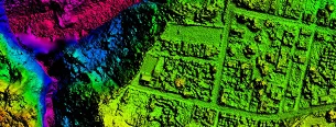
We take high-speed imaging and remote sensing measurements to produce highway corridor mapping, updated Planimetric features, and Orthophoto generation.
We produce base map layers for GIS products and full color Orthophotos for geometrically corrected features such as bridges and overpasses for use by mapping agencies.
Mapping
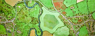
We specialize in capturing natural and man-made features for comprehensive GIS solutions or for individual projects.

We prepare detailed topographic maps showing geospatial disposition of utility companies’ assets and consumer indexing, and we update older topographic maps.
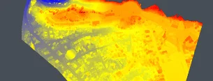
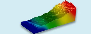
We use DEM data to model water flow and mass movements to evaluate floodplains, earthquakes and landslides and to calculate terrain slopes and volumes.
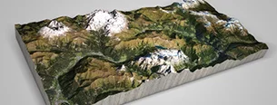
Modeling
We develop solid Terrain Models. Surfaces derived from LiDAR and photogrammetric techniques provide a framework for which a “skin” of realistic imagery is applied.
Mapping
We process LiDAR digital terrain models (DTM) for geologically unstable areas for Dam Site Constructions and Integration with Geological / Geophysical Information.

We understand every aspect of GIS design, including software and hardware requirements, to ensure the delivery of highly accurate GIS Base Maps and “GIS-friendly” products.
We perform computerization of land surveys, scanning, georeferencing vectorization, plotting and proof reading of old hard copy records.
Benefits of Outsourcing Geospatial to ICW
- We have the best professionals in Geospatial Technology and have a top technical team, who bring with them more than 15 years of experience in this field. So our clients can be assured of receiving delivery of the highest quality products.
- Our expertise in 2D/3D CAD modeling means you will receive the most accurate geospatial products possible.
- Our security protocols follow (and exceed) international standards to ensure your data is safe with us.
- Our techniques and project management skills assure consistent results and accurate deliverables.
- We have a proven track record of significant cost savings over other service providers in this field.
Get Started with our Geospatial Services Today!
ICW is a full-service provider of geospatial services, and our scope of services is second to none. This highly specialized field requires an immense investment in systems, people, and processes. If your company wants to expand by offering GIS services, you should talk to ICW. Avoid the investment required to enter this business by outsourcing Geospatial Services to us. You will only pay for what you use. And your clients will thank you for delivering proven products and services.
Click on the “Contact Us” button, below to learn how easy it is to work with ICW.